Table of Contents
LOW-COST AUTONOMOUS MAPPING PLATFORM (LAMP)
Students:
- ANKIT SARVAIYA
- FARIYA FARHAD
- KIRENDEEP RANDHAWA
Project Adviser:
Prof. COSTAS ARMENAKIS
Associate Professor, Geomatics Engineering, Department of Earth and Space Science and Engineering
Mentor(s):
- JULIEN LI-CHEE MING
- GOWRY SINNATHAMBY
Course Director
Prof. EBRAHIM GHAFAR-ZADEH
Assistant Professor , Dept. of EECS, York University
ABOUT LAMP
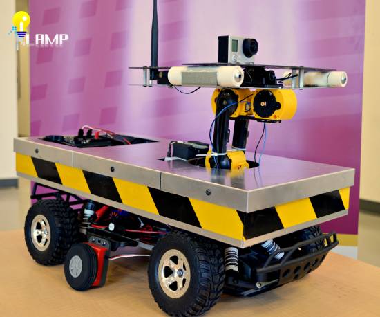
LAMP stands for Low-cost Autonomous Mapping Platform. This mapping technology uses camera imagery, precise laser modules and compass; integrated seamlessly in order to accurately measure distances, angles and depth to a target point relative to the platform itself.
PROJECT VIDEO
PROMOTIONAL IMAGE
PROJECT LAMP SUMMARY
Project LAMP, stands for Low-cost Autonomous Mapping Platform. The project selection stems from the fact that all the three members are currently final year Geomatics Engineering Students and understand the hardships faced by surveyors currently in the field. The aim of the project is to introduce an innovative mapping product in the industry which will be an economical solution to many of the fundamental obstacles presented in the field. In the proposed project, our team presents the unique designed low-cost autonomous mapping platform which uses a laser-visual range finding technique to obtain depth measurements. Stationed atop an unmanned ground vehicle (UGV), it is intended to be used for indoor and outdoor terrestrial surveying applications. The following functionalities had been integrated in the final design of the mapping platform:
- The platform is capable of obtaining 3D information of target points
- It can perform locational computation of objects in 3D space (in a local reference frame)
- Ability to measure, map and model
- The platform is portable and is completely customizable
The objective of this ENG4000 course was to understand the many different aspects of Engineering Design such as project planning, management and task delegation while solving an engineering problem by utilizing the knowledge obtained throughout these 4 years. The team managed their time effectively to deliver the final design in a timely manner from conception. The course director has constantly been informed about the design phase of the project through documentations and presentations. The team has been aided by a willing faculty member and also a couple of mentors who are Graduate students in the university. The team had been operating under a limited budget provided by the university to keep up with the low-cost feature of the product. They have been successful in all aspects. They have managed to produce a working solution that has immense potential with further research and sophistication.
GROUP MEMBERS
Our team is comprised of three ambitious Geomatics Engineering students from Keele Campus at York University, Toronto, Ontario, Canada. We have an enterpreneurial mindset as we approach our project in the hopes of creating innovation within the Survey industry. We have assembled the team with the necessary background knowledge regarding a project like this and also divided up the work according to the members' individual skillset. The contact information for the individual members of our team can be found at the bottom of this webpage.
 ANKIT SARVAIYA
Stream: Geomatics Engineering
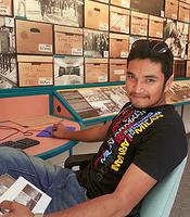
Ankit Sarvaiya is a fourth year Geomatics Engineering student who had been actively involved in many different land survey projects with Rady-Pentek and Edward Surveying Ltd. as well as the Engineering & Public Works Department at Vaughan City Hall. He is well aware of the limitations and difficulties faced by the field surveyors on a day-to-day basis. He manages Project LAMP, which is the realization of an affordable mapping solution which is portable and has real-world mapping capabilities. Project LAMP had been designed with the difficulties of the field surveyors in mind. As the Project Manager, his job was to overlook the entire process of the project from conception to the delivery of the final product. He was also responsible for enforcing deadlines and coordinating the individual team members accordingly.
Additionally, as the Hardware Engineer dedicated for the project, he was responsible for designing and implementing the hardware architecture of the mapping platform. He administered the configuration of all electrical components and computer connections on board the vehicle for user control.
 FARIYA FARHAD
Stream: Geomatics Engineering
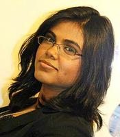
Fariya Farhad is a fourth year Geomatics Engineering major who also had worked within the survey industry with Rady-Pentek & Edward Surveying Ltd. Her interest lies in Geographic Information. She is in charge of the Software and Systems Architecture of the project, closely working with the Hardware Engineer to ensure seamless coordination. Her aim was to develop a software and interface which is user-friendly and also requires minimal user input in order to accomplish a given task.
Fariya also acts as the Creative Director of the project. She was in charge of the visuals and stylization of the entire project such as sketches, models, animations, posters, presentations etc. She also worked closely with Ankit to implement the overall strategy of the project.
 KIRANDEEP RANDHAWA
Stream: Geomatics Engineering
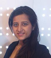
Kirandeep Randhawa is a fourth year Geomatics Engineering major who has extensive survey experience working with Rady-Pentek & Edwards Surveying Ltd in the past. She is the lead technical researcher of the group and provided extensive knowledge and training regarding specific technology implementations.
Kirandeep is also in charge of all process of networking for this project. She acts as the public spokesperson and presents the product, project updates and any related information to sponsors and other industry partners. She was in charge of note-taking, updating and documentation as the project went ahead. Along with the team leader, it is also her duty to maintain effective communication within the group members.
MEMBER ROLES
PROJECT OVERVIEW
BACKGROUND AND MOTIVATION
In surveying practice, a survey crew is always composed of two or more individuals. Party Chief being the head of the crew governs the surveying process throughout the working hours whereas, Instrument person is required to assist and record necessary information required by the party chief. In many situations, absence of an individual or unpredictable behavior of weather prevents surveying tasks from taking place. In order to solve such common problems in surveying industry; our task was to design and implement a mapping unit that can easily overcome such challenges.
Our project will be unique in a way that its objective would be to overcome different challenges faced in the field of land surveys. There are similar products which have been introduced in the past but they all specialize in different areas. For example, some are built for defense purposes and are widely used by the warfighters and public safety professionals. There are designs based on laser mapping and navigation, with the advantage that it could work on any kind of environment with varying ground surface such as warehouses, lab spaces or mountains. But with these advantages, comes an upsurge of cost. Recently, Trimble produced X50 and X100; autonomous flight units that can obtain photogrammetric information and attach the necessary parameters to it. Such systems are very expensive for the task they perform. Our goal behind this project is to minimize the overall cost of the system while maintaining the quality of surveying observations to that of found in industrial grade survey equipment.
PROJECT SCOPE
In the proposed project, we consider the problem of low-cost autonomous mapping platform with navigation capabilities intended to be used for indoor and outdoor ground surveying applications. In particular, we are interested in keeping human interaction, communication and external input at a minimum while obtaining necessary results with acceptable standards of accuracy. The end product of our project consists of a customized ground system capable of the determination of 3D object coordinates located within the indoor/outdoor environment and the necessary supplementary software tool required to obtain and manipulate the collected data by the end user. The majority of the focus is confined to the indoor aspect of a surveying task.
Once the project scope had been finalized, the group determined the approximate list of hardware components that was required in order to develop the platform and also remain within the allocated budget. With the list in mind, a budget sufficient for the prototype and also a contingency plan was put in place to ensure backup in case of any emergency. Our team also worked towards securing external sources of funding from sponsors. With all the above in mind, the following table had been arranged to visualize the entire project scope (Note that the project had been divided up into 6 phases):
DESIGN OVERVIEW
The following flowchart shows the entire design overview for this project. Since LAMP is mainly used for mapping, the Mapping Component is the most important module for the entire project which has been uniquely designed by the team. The Post-Processing module follows next in terms of importance as heavy processing is required to obtain the finalized positional data of a target object/ area.
HARDWARE ARCHITECTURE
SOFTWARE ARCHITECTURE
IMPLEMENTATION TECHNIQUE
These are the main implementation tools which are being implemented by our team to build LAMP. These arose through rigorous technological/technical research, previous employment experience also the learned knowledge having been on the Engineering program for four years.
MAPPING COMPONENT
LASER-VISUAL RANGE FINDING PLATFORM (T-PLATFORM)
HOW IT WORKS?
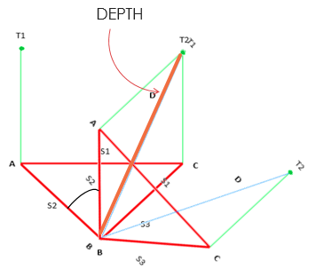
A pair of laser beams are shot on a target point or object from the mapping platform. The laser beams being parallel, create a unique geometry when they are marked on the target. The platform is then rotated so that one of the previous position of the laser dots are overlapped by the other one. This creates a geometry which when combined with the precisely measure rotational angle, the user is able to compute the Distance, Angle and Depth from the point of view of the platform to the target object. That is how the device works in a nutshell.
POST PROCESSING
POINT ⇒ LINE ⇒ AREA
From the capture of one point from a camera image, a line of points can be obtained from a continuous video. Building up these lines will eventually enable the platform to map an entire area.
IMAGE PROCESSING TECHNIQUES
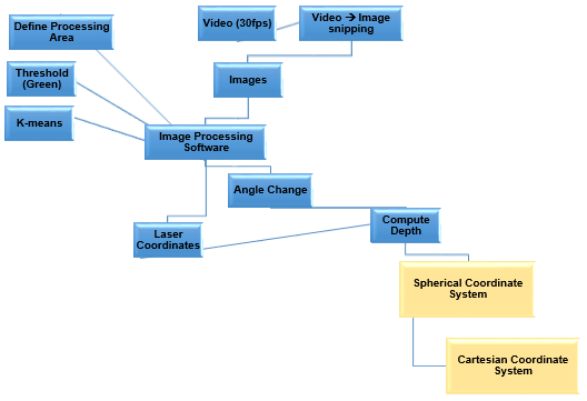
The following flowchart shows the image processing route taken in order to obtain the final results. Image processing is used to process camera and video imagery in order to locate laser dots and subsequently, find range information.
SOME EXAMPLES OF IMAGE PROCESSING
Detection of the Laser Dots Location:
Edges/ Points of Interests Location:
Planar Distance Measurements:
Face Recognition Safety Feature:
RESULTS
- Image Processing Algorithm used to process video/camera imagery
- Many different techniques used for point positioning of camera objects (described in the previous section)
- Final Result: Gradual build-up of points to obtain 3D point cloud
POINT CLOUD
The following 3D point cloud of a specific target area is visualized in terms of depth, using colour gradients, identifying objects that are nearer and further from the point of reference of the instrument.

FUTURE PROSPECTS
The demand for high accuracy 3D model has rapidly increased in many fields such as engineering, architecture, surveying, deformation monitoring, transportation, automobile industry etc. Generating a 3D point cloud model within the desired accuracy level is of high demand in the industry and LAMP has been able to achieve this so far after only one year of research and development.
Point clouds can be directly rendered and inspected. They can also be transformed or converted to polygon mesh, triangle mesh, surface models or CAD models. These collectively can be described under the following umbrella terms:
- 3D Modeling
- 3D Scene Reconstruction
- Surface Reconstruction
Starting from the generated cloud, LAMP therefore offers the ability to Measure, Map and Model a given target object or area.
An example of different types of model visualization:
An example of 3D modelling from point cloud:
NOVELTY AND FUTURE INNOVATION
The following points summarize the novelty of a product as LAMP:
- Uniquely designed 3D mapping system uses two lasers, one camera to produce 3D maps of arbitrary indoor environment.
- Separate Laser Range System. Uniquely designed by the team (T-Platform).
- Functions well with different types of camera quality.
- Customizable and can work with different visual or ranging sensors as well.
- Effective and affordable robotic platform.
- Sophisticated visual techniques.
- Produces comparable accuracy within its high effective range.
This product also has the potential to bring innovative changes in many different Geomatics fields. The possible future innovation is summarized below:
- Survey Industries - capture 3D positional data in areas of no GPS coverage.
- Construction Purposes- Mapping neighbourhood location and buildings that needs to be constructed.
- Transportation industry – Modeling smart transportation.
- Automobile industry – Mapping assembly line and modeling prototype.
- Defense and Public health safety.
SPONSORS
Thanks to these sponsors who have provided us with continual technical and non-technical support throughout the project duration:
- Traxxas
 Traxxas is a radio control model manufacturer based in Texas, United States. They design and manufacture hobby-class radio controlled cars, trucks and boats with a choice of nitro or electric engines. Our unmanned ground vehicle (RC car) was obtained from this sponsor.
- AMP Promatic Inc
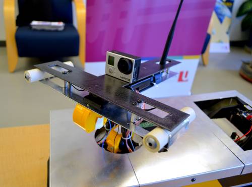
 AMP Promatic Inc specializes in custom designing of equipment, CNC machining, tool and die capabilities. They manufactured the aluminum chassis and T-platform for our project based on our design specification. The aluminium chassis houses all the electrical components and provides the base for the mapping platform (T-Platform). The platform is the main component which will be mounted on top of the 5-DOF edge robotic arm.
- Vaughan city Hall (Engineering & Public Works Department)
 This municipal organization helps us determine the accuracy of our autonomous platform as it specializes in Land Surveying tasks. The survey data or other geospatial information obtained from the engineering department of Vaughan city hall has been used to compare it with the results obtained from our robotic platform.
FUNDING
CONTACTS
ANKIT SARVAIYA
ankit1@yorku.ca
FARIYA FARHAD
xystus@yorku.ca
KIRANDEEP RANDHAWA
kiran90@yorku.ca
PROFESSOR COSTAS ARMENAKIS
(Academic Advisor)
http://lassonde.yorku.ca/users/costasarmenakis
Project Update Videos
- Motion Trackinghttp://www.youtube.com/watch?v=vF_P6KipGPo&feature=youtu.be
- Object Coordinateshttp://www.youtube.com/watch?v=vF_P6KipGPo&feature=youtu.be
