Table of Contents
Group 8
CampNav
Students:
Alec Mantha
Phillip Robbins
Maninder Gill
Patrick Eagan
Project Adviser:
Dr. Gunho Sohn
Associate Professor, Co-Director of GeoICT Lab
Mentor(s):
Solomon Chan
Hadi Abdel
Young-Min Cho
Hossein Pourmodheji
Mourad Amara
Course Director:
Professor Ebrahim Ghafar-Zadeh
Assistant Professor , Dept. of EECS, York University
Group Members
Alec Mantha
 Stream: Geomatics Engineering
Title: Project Manager
Role: I was the Project Manager throughout the design and implementation phase of CampNav, together with Phillip I additionally had a hand in working on the indoor positioning algorithm of the project. The project manager’s duty was to make sure the project got completed within the specified deadlines as well complete a lot of the clerical tasks along the way. Throughout the project I would be making sure that reports got written and submitted on time to both Professor Gunho and Professor Ebrahim. In doing so I had to be the person to book meetings, answer all issues which appeared along the way as well figure out ways to integrate individual systems. Some of the technical tasks for the project I performed along the way will be outlined below:
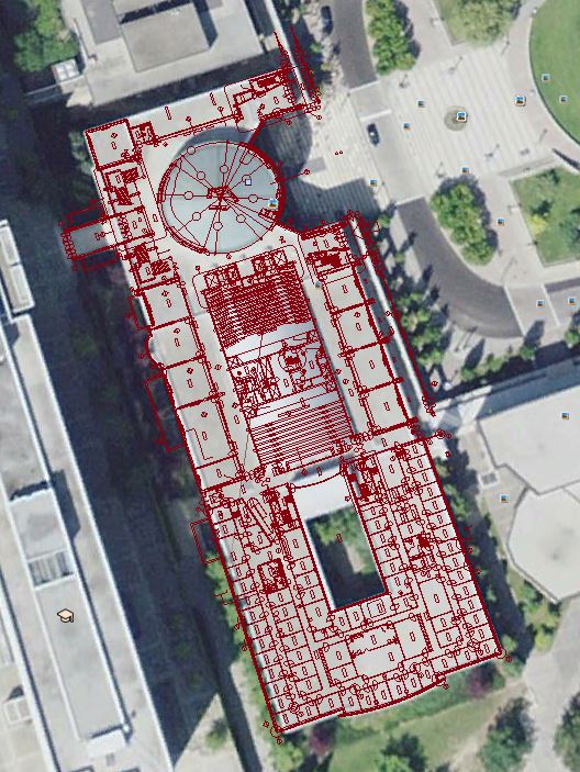
Georeferencing Floor Plans: I figured out a method to take the un-georeferenced architectural autocad file and use programs such as ArcGis and matlab to assign UTM coordinates in order to be correctly overlaid in software such as Google Maps. This was performed using an affine transformation like what is outlined in the report.
Georeferenced the Finger Print Grid: I made a matlab function and together with aerial images of the York Campus was able to estimate the UTM coordinates for 3 of the grid points and using least squares compute the Lat Long Coordinates for the whole grid. This was a simple affine transformation however still uses fundamental skills learned in Geomatics Engineering.
Heat Maps: I was in charge of taking the Signal Strength data of each finger print and fit a second order polynomial curve to it in order to create Heat Maps of the grid. These Heat Maps were discussed earlier on in this report.
Scanning and Testing Grids: I assisted in the scanning and statistical testing of both the grid and the app in general. This was done as outlined in the Results section of this report.
Assisted in Writing Location Algorithm: Phil and I worked together in order to research and design the algorithm from its roots as a simple matlab test function to its fully implemented Android program.
Phillip Robbins
 Stream: Geomatics Engineering
Title: Programmer
Role: Phillip together with Maninder were the main Android API programmers in CampNav. They were set to focus on the two different segments of the application. The indoor positioning and was Phillip’s main focus while the Augmented Reality was Maninder’s main focus. In order to meet the requirements of our Supervisor, both of these applications were to be created in unison.
Indoor Algorithm Programming: Phil was the primary programmer of the Indoor Positioning. He took lead when it came to all things Android programming especially when implementing the Google Maps API. Phillip worked together with Alec in improving the performance of the indoor positioning algorithm. The testing and validation of the Indoor Positioning Algorithm was a two man job and required vast amounts of different statistical analysis and testing to come with the best quality of Positioning possible.
WiFi Surveying Software: Phil in addition to the main Indoor Algorithm Programming designed and implemented the system of which the fingerprints were surveyed. His software which was outlined in the report read the Wi-Fi information for a set period of time and saved it into a text file which could later be interpolated with systems such as Matlab or Java for pre-processing.
Implemented Pre-Processing Matlab codes: Phil wrote Matlab code which was capable of taking the raw “WiFi Surveying Software Outputs” and pre-processing them such as averaging out the signal strengths, and writing them into a sparse matrix style data base. This was done in order to reduce runtime calculations. In addition this software greatly improved the CampNav systems load time when it was activated.
Took part in the Wi-Fi Surveying of both Lassonde A and Vari Hall:
Phillip assisted in scanning the wifi signal data of these two areas. In Vari Hall the original grid had a resolution of just 1m. This created a situation in which the group spent about 3 days measuring the test area’s wifi-fingerprints.
Patrick Eagan
 Stream: Geomatics Engineering
Title: Surveyor
Role: Patrick was in charge of surveying the test grid and as such spent the most time in Vari and Lassonde organizing where the test grid would be laid out. This was vital in the creation of a test grid in which statistical tests could be performed in order to access the availability of this system.
Maninder Gill
 Stream: Geomatics Engineering
Title: Lead Augmented Reality Programmer
Role: I was one of the main programmers during the building phase of CampNav. I have developed the algorithm for the Augmented Reality browser in CampNav and translated and integrated its various components into the Android code (Java). I also integrated various components of CampNav and tested them for errors and reliability of the results. During the course of project, I also made sure along with fellow group members that all the technical reports are written and submitted on time to Prof. Ebrahim and Prof. Gunho. As one of the main programmer of CampNav, I was working very closely with our clients specifically our Advisor Prof. Gunho Sohn during the course of the project to make sure that all the requirements of our clients are realized in Algorithms. Following are the main tasks that I performed during the course of the project:
Integrating our location algorithm and sensors in the device: In order to obtain the right location and orientation of the user, I integrate our location algorithm, GPS, accelerometer, magnetometer of the device to get a final output on the screen. Since all these components are functioning together, and malfunctioning of one have a big impact on our results. So, while programming I made sure that all the components are doing their assigned tasks and various checkpoints are realized in the code to figure out if one of component is not working as desired.
Overlaying Maps I also worked with fellow group members to overlay the final location obtained from our location algorithm onto the indoor floor plans and Google maps to show the exact location of the user. I also spend few weeks developing an algorithm, which allows user to select a point on the map(from his/her known location) and then, gives user the shortest distance and direction to that point. But due to the complexity of the algorithm, and keeping in mind our clients needs, we decided not to integrate this algorithm in our working app at the moment. But we are open to integrate this feature in CampNav in future according to customer’s requirement.
Data Collection: For the database of our location algorithm I assisted in obtaining the fingerprints, which are later, used to locate the position of the user indoors.
AR browser: I was in charge of developing the AR (Augmented reality) browser for CampNav. Firstly I developed the Algorithm by working closely with our Advisor Prof. Gunho Sohn to make sure that I understand his client’s needs properly and all those needs are incorporated into the Algorithm. Then I translated this Algorithm into an actual AR browser in Android platform by developing various scripts and integrating the pre-existing scripts. Results are tested time to time and errors have been analyzed and removed from the application by understanding the root source of the errors. Changes have been made time to time by having constant meetings with our Advisor Prof. Sohn in order to improve the results of AR algorithm. Please refer to the Augmented Reality section of the report for the detailed explanation of the Augmented Reality.
Description of Project
Background
This project is all about positioning oneself for navigation without the need for receiving GPS signals. We all know that inside a building it is virtually impossible for the GPS signal to penetrate the walls, and the signal that is found has such high multipath attached to it that the position cannot be found to a high enough accuracy. Multipath is errors in signal quality caused by signals being deflected off of objects such as buildings, trees, or even the person holding the receiver. The multipath on the signal can be compounded to an extreme degree which can make the positional accuracy nonexistent. WiFi routers or they’re technical name IEEE 802.11 are what we determined to be the best solution to the multipath problem stated before. The router sends out a signal with a given known power, based off of the power analyzed at the receiver it will be able to determine the signal strength in db. By recording the signal strengths of multiple routers a fingerprint database can be created. This database will consist of a weighted averaged signal strength value which will uniquely identify each and every point spatially.
This idea is relatively new with only about a dozen or so competing start up companies including such highlights as Point Inside which is one of the largest competitors in the field specializing in indoor positioning for such aspects as retail and WiFi slam which was recently purchased by Apple for $20million. We believe our software to be different in the respect that it is primarily focused towards moving handicapped people around campus safely and securely. For this reason some of the most important information which must be surveyed is the small obstacles which effect primarily people with disabilities. This includes such things as stairs, ramps, handicap accessible doors etc.
Project Scope
In this proposed project we will be creating an indoor navigation and positioning system which will be set up initially for the Vari Hall building in York University. This project is primarily focused towards helping disabled people navigate around campus. People with disabilities have different sets of problems then people without them. They need access to ramps, elevators, and pushbutton open access door among other things. In order to provide this service we will need to create an indoor positioning system for the campus. This can be done by logging WiFi signal strengths around campus and creating a “Fingerprint Database” which compares the WiFi signal strengths with a spatial database containing important aforementioned POI's above for navigation of the disabled. This database will be represented with ArcMAPS style floor plans showing your location and the routes you desire to take. The project will additionally incorporate aspects of augmented reality in order to show to help the user with navigational issues in the indoor environment.
Deliverables
- Develop a fingerprint map of Campus (Vari Hall for the scope of this ENG 4000 project)
- Develop a georefrenced ArcMAP representation of the Vari Hall building
- Develop an algorithm to determine the fingerprint solution using WiFi signals
- Develop an application to display the Maps on an android device real time
- Develop a method to show augmented reality in a way to help navigation.
Achieved Results
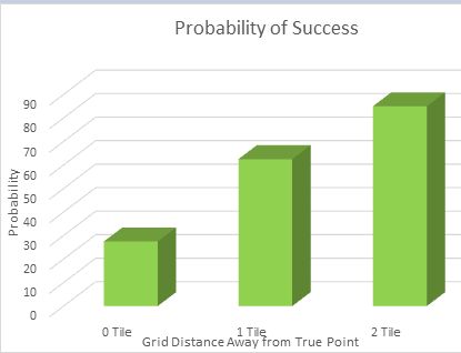
CampNav's indoor positioning system is capable of positional accuracy with a resolution of approximately 5m however it is subject to more performance enhancements. This custom made algorithm analyzes the signal residuals to the fingerprint database in order to display the results to the user. These results are then taken and overlaid onto Google Maps using the grid points proper UTM coordinates.
With this graph the tile distances represent moving one fingerprint over or equivalent to 3.65m
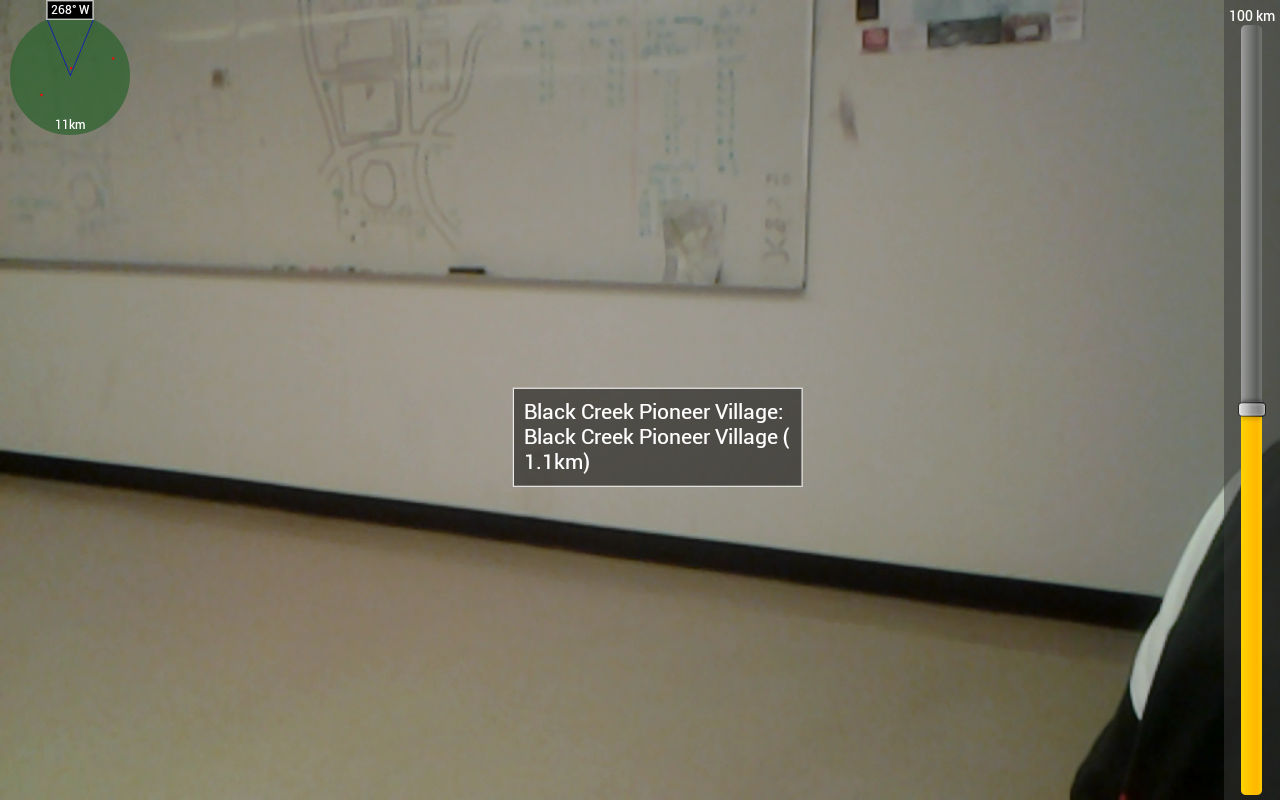
CampNav currently has an augmented reality service which has access to Google Places, in order to show any Google Place with a desired upon distance from the user including Azimuthal directions. This AR functionality is able to show the locations of Google Places on top of the live feed rear-facing camera.
Images ( Setup/Schematics/Results)
The current augmented reality navigation system.
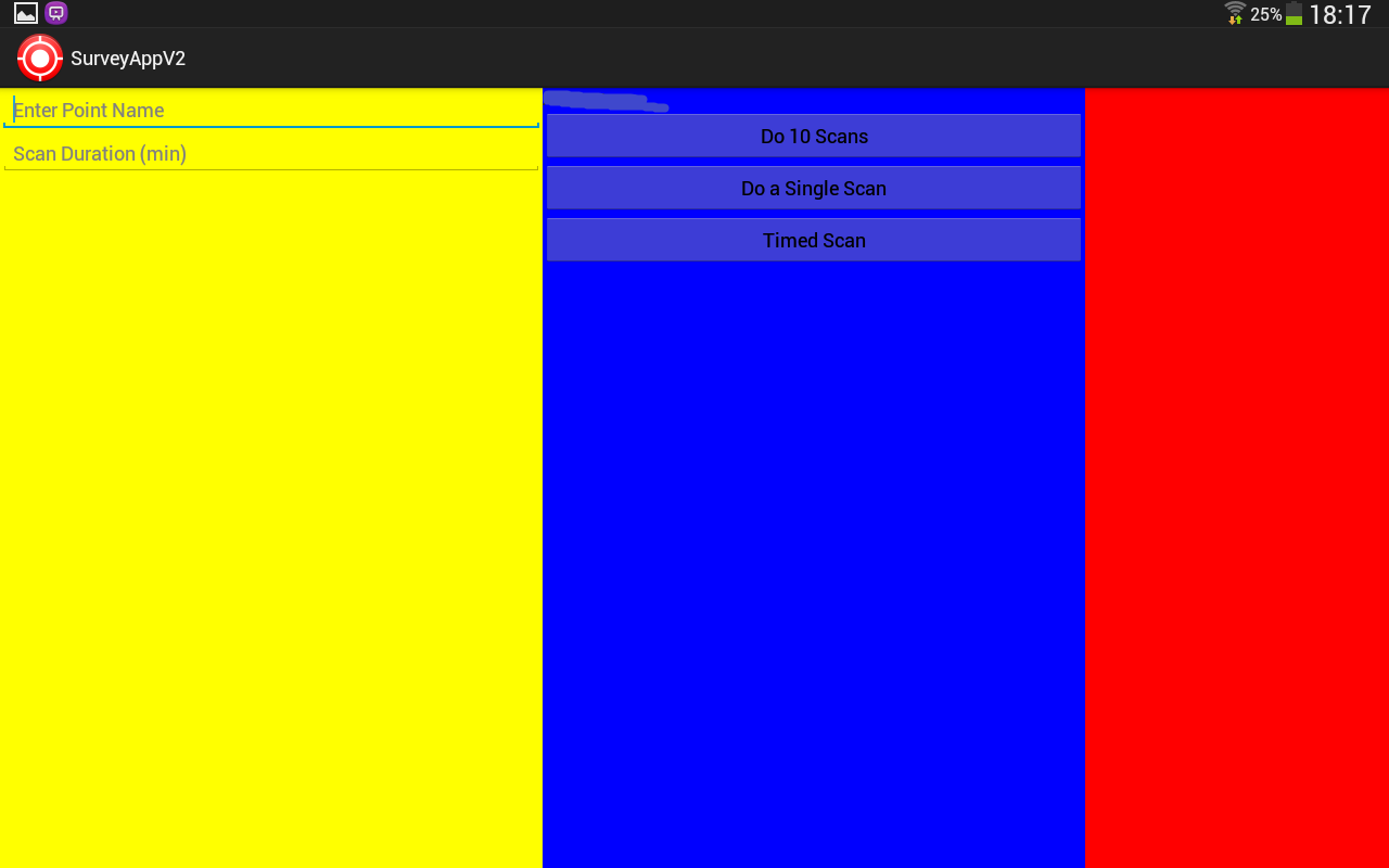
This is user interface so far developed for our surveying app.
This is an example of a fingerprint of a single location.
 This is the group monumenting the grid in Vari Hall, with masking tape.

This is the coordinate system used as well as the setup for logging data.
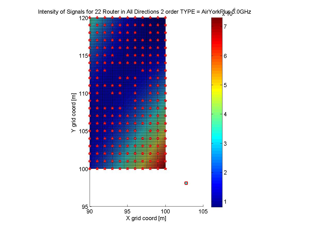
This is the heat map of signal intensities for all routers in all directions.
The 2D heat map of one AP with the AP's location labelled
This is the georeferenced "rough" floor plans displayed on Google Earth using a .kml
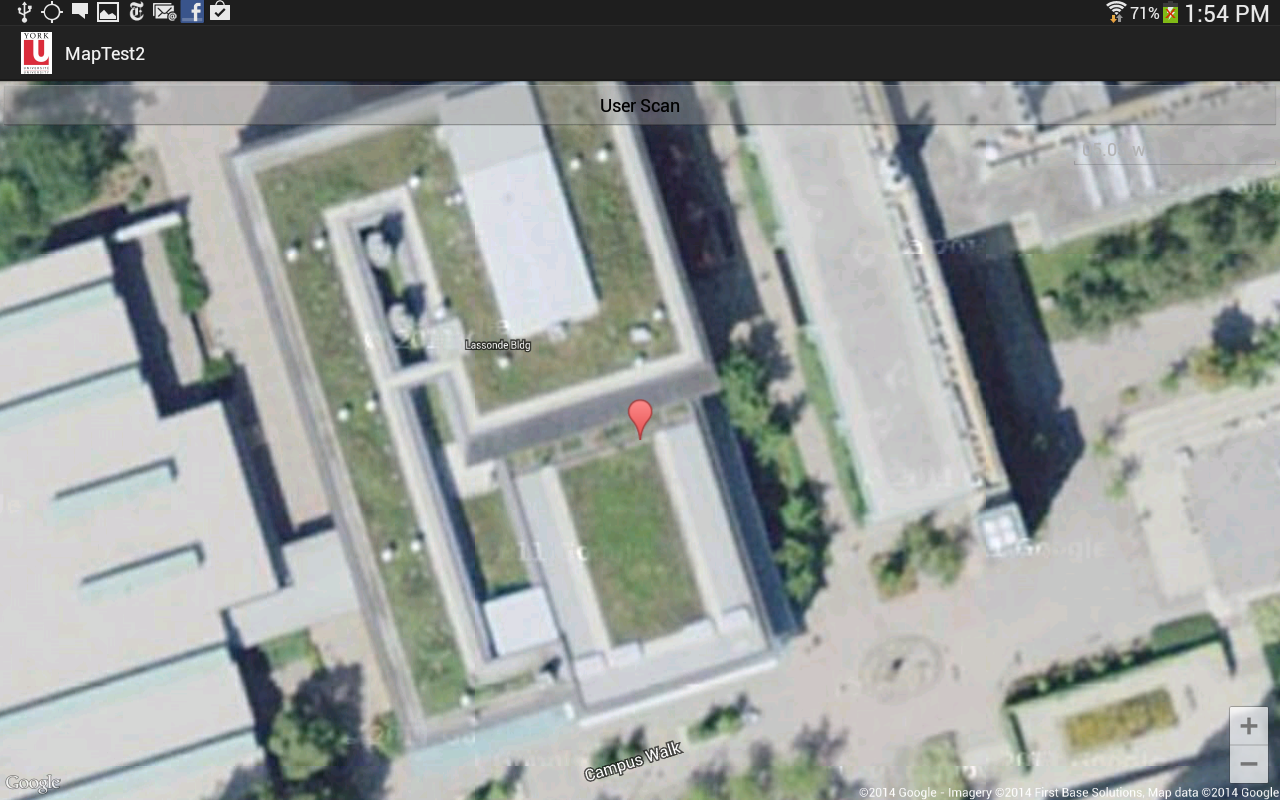
This is an example of the map solving the location of the user and placing the google marker over the calculated point.
Funding
- Lassonde School of Engineering ( $1000),
Contributors
Latest Presentation
- backgroundreview.pptx Presentation Oct. 24th, 2013
- campnav_-_critical_design_review_1.pptx Presentation Nov. 8th, 2013
- project_timeline_table.pdf Timeline of project with the requirements of each step
- campnav_-_critical_design_review_2.pptx Presentation Nov. 27th, 2013
- campnav_-_critical_design_review_3.pptx Presentation Dec. 23rd, 2013
- report1.pdf Report 1 Jan. 22nd, 2014
- campnav_-_critical_design_review_4.pptx Presentation Mar. 26th, 2014
- campnav_-_critical_design_review_4_final_class_.pptx Presentation Apr. 2nd, 2014
